Sensing Construction Dynamics (SeCD)
I am currently pursuing a Ph.D. in Civil Engineering at Georgia Tech, advised by Dr. Yong K. Cho. As a member of the Robotics and Intelligent Construction Automation Lab (RICAL), my research focuses on construction automation, with an emphasis on 3D scene understanding using LiDAR and vision sensors, UAV- and UGV-based data collection, and Scan-to-BIM technologies.
At Seoul National University, I worked in the Spatial INformatics group under the supervision of Dr. Yongil Kim and Dr. Kiyun Yu. Following that, I gained brief experience as a GIS-focused startup entrepreneur, leading a government-funded project on business site selection.
Interests
- Construction Automation- UAV/UGV
- 3D Scene Understanding during Construction
- Digital Twin; Scan2BIM
- Computer Vision; Generative AI
- Geographic Information System (GIS)
Education
-
Ph.D. in Civil Engineering, 2021 ~ present
Georgia Tech, Atlanta, Georgia
-
MS in Computer Science, 2024
Georgia Tech, Atlanta, Georgia
-
MS in Civil Engineering, 2019
Seoul National University, South Korea
-
BS in Architectural Engineering, 2017
Seoul National University, South Korea
Projects
![Indoor Reconstruction [Korea MOLIT, Jul. 2017 – Dec. 2020]](/project/2020-indoor/featured_hu53cef8c9ec1a8a63161258650392b915_2097013_550x0_resize_lanczos_3.png)
Indoor Reconstruction [Korea MOLIT, Jul. 2017 – Dec. 2020]
Floorplan Analysis: retriving the indoor structure from floorplans
![GIS- Consulting Location Allocation as an Adversory Researcher [Samsung Economic Research Institute, May–Jun. 2020]](/project/2020-seri/featured_hu93eb2c34708d457bd50dbb15bdcd8b06_122942_550x0_resize_lanczos_3.png)
GIS- Consulting Location Allocation as an Adversory Researcher [Samsung Economic Research Institute, May–Jun. 2020]
GIS consulting based on open source software (QGIS)

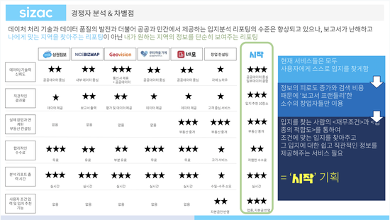
Startup- recommending starting locations to new business owners
Funded by Korea Ministry of SMEs and Startups; a MVP will be ready by Jan. 2021
![GIS- Updating Land Category in Cadastral Map Using Hyperspectral UAV [Korea LX, Jan.–Dec. 2019]](/project/2019-landcover/featured_hu3e488ba09ccb57c11b5229d114d3170b_871438_550x0_resize_lanczos_3.png)
GIS- Updating Land Category in Cadastral Map Using Hyperspectral UAV [Korea LX, Jan.–Dec. 2019]
Cadastral Map; Discrepancy Analysis; Land Update; Hyperspectral UAV; Land Classificaion; 3D-CNN; Integration Analysis

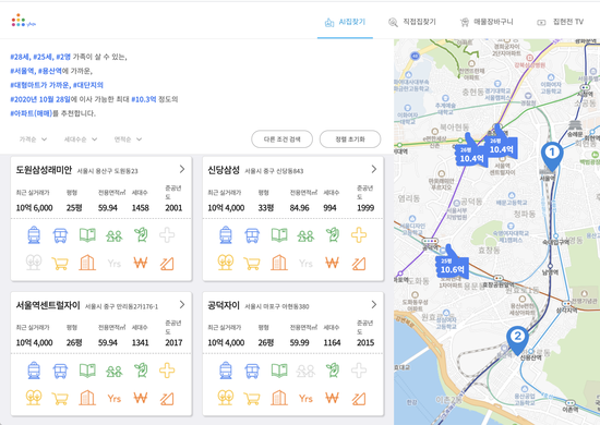
Startup- launching the web application on real estate in Korea
집현전, the web service for recommending real estate to customers and linking them to real estate agents with low broker fees.
Recent News
[Oct. 2021] One paper got accepted at ISARC 2021
[Sep. 2021] Presented the i3CE conference paper in Orlando, Florida.
[Jul. 2021] We (GTS2B) ranked second in the 2D floorplan reconstruction category at 1st Workshop and Challenge on Computer Vision in the Built Environment, CVPR.
[Jul. 2021] Two conference papers got accepted at i3CE 2021
[May 2021] I joined the RICAL research team and am pursuing my Ph.D. under Dr. Yong K. Cho.
