GIS- Updating Land Category in Cadastral Map Using Hyperspectral UAV [Korea LX, Jan.–Dec. 2019]
 Discrepancy analysis for updating the land category in parcel maps
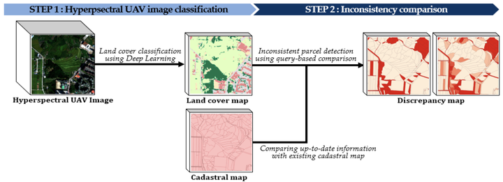
With the perspective of automation, we perform discrepancy analysis for detecting parcels that should be updated using hyperspectral UAV images.
- An up-to-date land cover map is generated from hyperspectral unmanned aerial vehicle (UAV) images. These images are effectively classified by a hybrid two- and three-dimensional convolutional neural network.
- A discrepancy map, which contains the ratio of the area that is being used differently from the registered land use in each parcel, is constructed through a three-stage inconsistency comparison.
The method automatically reveals the inconsistent parcels requiring updates of their land category. Although the performance of the proposed method depends on the classification results obtained from UAV imagery, the method allows a flexible modification of the matching criteria between the land categories and land coverage. Therefore, it is generalizable to various cadastral systems and the discrepancy ratios will provide practical information and significantly reduce the time and effort for land monitoring and field surveying.
Seongyong Kim
Graduate Research Assistant
I’m a grad student in CEE at Gatech. My research interests include consturction automation, 3D scene understanding on active sites.